


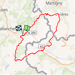
TMB - Etape 1 à 9
© OpenStreetMap contributors


56h50
Difficulty : Difficult


Length
147 km
Max alt
2672 m
Uphill gradient
11427 m
Km-Effort
299 km
Min alt
976 m
Downhill gradient
11426 m
Boucle
Yes
Creation date :
2014-12-10 00:00:00.0
Updated on :
2014-12-10 00:00:00.0
56h50
Difficulty : Difficult
FREE GPS app for hiking
 SityTrail
IGN / Geographical institutes
SityTrail Plus
The world is yours!
About
Trail Walking of 147 km to be discovered at Auvergne-Rhône-Alpes, Upper Savoy, Les Houches. This trail is proposed by maxime.ranchin@aliceadsl.fr.
Positioning
Country:
France
Region :
Auvergne-Rhône-Alpes
Department/Province :
Upper Savoy
Municipality :
Les Houches
Location:
Unknown
Start:(Dec)
Start:(UTM)
327818 ; 5084808 (32T) N.
Comments